
Research
Ek Tzul Chronology and Development
I am currently conducting excavations at the site of Ek Tzul near the modern town of Georgeville in Cayo District, Belize. First seen on Lidar in 2013, Ek Tzul has only been excavated since 2022. Very little is known about the site. My project seeks to map the site and understand the evolution of the site from when the hilltop was first inhabited until it grew into a large minor center. This research is grounded in panarchical theory which views the world as hierarchically connected systems where each system individually cycles through phases of growth, conservation, release, and reorganization. These individual systems are dynamically connected to other systems at various scales. Therefore, the growth of Ek Tzul is not viewed as linear but cyclical.
You can read more about my work in my recently defended dissertation proposal here and several site reports here!
Belize River Valley Climate Change and Faunal Utilization
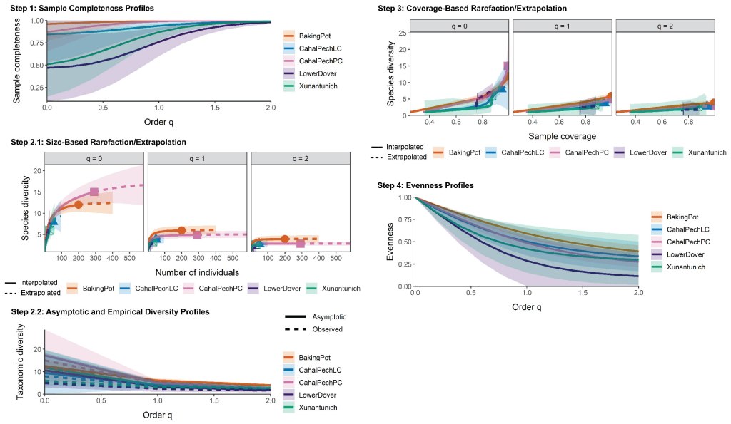
Many models have been proposed to explain the disintegration of Classic Maya polities including those based on climate change, inter-site competition, warfare, and environmental degradation. It is now clear, however, that multiple simultaneous factors were involved, and the combination of factors varied from one region of the Maya Lowlands to another during the Late to Terminal Classic periods (AD 750-900/1000). As such, each region must be examined individually to understand the processes that contributed to depopulation to explain why some regions were more resilient than others. In the upper Belize River Valley in the eastern Maya Lowlands, a series of droughts during the Terminal Classic has been attributed as one factor underlying the abandonment of centers. Using Hill diversity metrics (richness, Shannon diversity, and Simpson diversity) as measurements of diet diversity, our study analyzes Preclassic (1100/1000 BC-AD 300) and Late/Terminal Classic fauna from the sites of Baking Pot, Cahal Pech, Lower Dover, and Xunantunich to test models of environmental degradation and the adaptive cycle. The results show that the ancient Maya of the region responded to climate stresses through environmental resource management. Any rigidity in dietary preferences was mitigated by exploiting a broad spectrum of animal and plant resources.
The results of this research was published in Environmental Archaeology.
Belize River Valley Landscape Use
Fauna is not just indicative of diet but also of the types of ecosystems that were present for the Maya to exploit. Through the examination of species frequencies and their preferred habitats (as quantified by habitat fidelity), the prehistoric mosaic of ecosystems can be reconstructed. This is useful in understanding ancient Maya land use and changes in landscape through time. This also is important for understanding climate change as shifting land use may also lead to less stable systems.
I have been involved in collaborative research that has also approached this using soil data. This research concludes that settlement in the valley was correlated to soil productivity. Publications detailing this work can be found in Land, Ancient Mesoamerica, and Quaternary Science Advances.


Virtual Zooarchaeological Comparative Collection
Zooarchaeological comparative collections are a necessary resource for conducting faunal analysis of prehistoric and historic sites. The resulting analysis enables archaeologists to reconstruct aspects of past life ways including diet and ritual and political activities. However, comparative collections are expensive to build and maintain. Barriers include access to species from the regions studies, to facilities to process modern specimens into clean bone, and to facilities to curate the comparative specimens. Often, small universities, CRM firms, or other institutions with inadequate space or funding are unable to house their own comparative collection. This leads researchers to have to coordinate with institutions that do have comparative collections, though further barriers hamper these efforts such as access fees and distance from the institution.
Recent advances in photogrammetry and laser scanning enable institutions without the necessary resources to have access to virtual comparative collections. Through the process of photographing or scanning elements from a variety of species, 3D models can be created that can be disseminated digitally. Online repositories of 3D faunal elements enables researchers to access an applicable comparative specimen from anywhere, even in the field. This access results in better identification, the ability to distinguish between human and non-human in the field, and overall better understanding of the past.
Museum of Anthropological Archaeology
3010 School of Education Building
610 E. University Ave.
Ann Arbor, MI 48109
